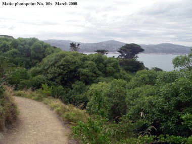
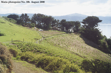
A picture is certainly worth a thousand words and that is why photo points can be immensely valuable as part of a monitoring project. One of the simplest and cheapest ways to monitor change in a plant populations, in your covenant or in a plant community is to establish photo points. These are fixed locations on the edge or within your site from which you take a photograph and compare against previous images taken from the same spot and from the same direction.
When setting up photo points there are some guidelines to follow:

 Minimising shadows is good, so as a rule photographs should be taken on overcast days. They should also be taken at the same time of day and a tripod should be used to standardise the height at which the photo is taken. A card with details about the photo point and the date and time may also be included with the photographs or this information can sometimes be programmed into your camera to appear on the photograph. The information recorded for photo points should be precise because it may not be you re-taking the photos in future years. Photographs should be re-taken at the exact position of the original photo point and all variables (camera specifications, height) should be replicated from one visit to another. Photopoints on Matiu/Somes Island, Wellington Harbour (left taken in 2000 by Jeremy Rolfe, right taken in 2008 by Brent Tandy).
You must locate a sufficient number of photo points so that the photographs will be representative of the whole site. It is critical that photo points can be re-located. Permanent marker pegs can be used to show where the tripod was positioned. You may also want to record its location on a map of the covenant or an aerial photograph or with a GPS unit.
Finally, it is helpful to draw a sketch map of the photo point and to aid relocation, take a photograph of the photo point with the marker peg in position. When taking photographs and recording details it is recommended that you follow the above guidelines.
Re-measuring the photo points is simple when their location has been recorded in sufficient detail and the information and original photographs were collated and stored at the completion of the initial fieldwork.
Images from photo points should be curated immediately after monitoring is completed. The electronic image or hard copies of the image should be marked (on the file name) to show when and where it was taken and by whom. Analysis over time of these photographs can provide a valuable insight into how the site is changing and whether different management is required to protect it.
Photo points do not provide quantitative data but the images can be used to show the changes occurring at a site.
For more information about photopoints see*:
- Recording ecological changes in your covenant using photopoints (QEII Trust website)
- Photopoints (Environment Bay of Plenty website)
*The Network is not responsible for the content of external internet sites
